
Hadosiddapura, off Sarjapur Road

Mythri Sarjapur location

Where the site actually is, and how far everything is by road rather than across the map. The short-range map is strong; the metro is a drive.

Mythri Sarjapur address on the filing

Mythri Sarjapur is the working title used on this site; Mythri Builders has announced no marketing name and has published nothing about the development. What exists is a government filing with an address precise to the survey number, and every distance below is road distance from the centre of the filed boundary, never a straight line and never a drive time. Inside the Bengaluru search area, Nambiar Bannerghatta helps buyers keep the map conversation grounded in actual routines instead of only distance claims.

Standard Terms of Reference were granted on 27 May 2026, the environmental clearance application filed on 17 July 2026 is under verification, and the project is not registered with the Karnataka Real Estate Regulatory Authority. Under Section 3 of the Real Estate (Regulation and Development) Act 2016 it cannot lawfully be advertised, booked or sold before registration, so this microsite is an information and enquiry resource, not a booking channel.

FieldAs recorded on the filing
Survey numbersHadosiddapura Village 25/1, 25/4, 25/5, 26/1 to 26/5, 27/3, 27/5 (code 613120); Chikkanayakanahalli Village 28/5, 28/10, 28/12, 28/13, 28/14 (code 613121)
Hobli, taluk, districtVarthur Hobli, Bengaluru East Taluk, Bengaluru Urban District
Promoter of recordMythri Builders, Broadway Building, 27th Main Road, Sector 1, HSR Layout, Bengaluru 560102
Filed programme993 homes in 7 blocks over two basements, ground and 20 upper floors, with a club house, on 4.4641 hectares, which is 11.03 acres
Project cost₹424.91 crore, declared on the application
Terms of ReferenceSIA/KA/INFRA2/578619/2026, filed 23 May 2026, Standard ToR granted 27 May 2026, File SEIAA 185 CON 2026
Environmental clearanceSIA/KA/INFRA2/584253/2026, filed 17 July 2026, under verification
K-RERA registrationNone

Bengaluru East is a revenue taluk inside Bengaluru Urban District, not a city zone, and that is what a khata extract carries.

This is a separate scheme from the firm's registered work nearby. Mythri Sity, Sy. No. 67/2 Kodathi, 468 homes, is PRM/KA/RERA/1251/446/PR/300525/007802; Mythri Street, Sy. Nos. 67/3 and 67/11 to 67/13 Kodathi, 219 homes, is PRM/KA/RERA/1251/446/PR/151025/008172; Mythri Sikharam, on a different Hadosiddapura parcel at Sy. Nos. 48/4 and 48/8 to 48/10, 182 homes, is PRM/KA/RERA/1251/446/PR/280525/007790. Sapphire and Signature are completed deliveries within about a kilometre, and Mythri Sankalp DKM is 16 km away at Halehalli on the K R Puram side. This parcel has its own survey numbers and no registration number.

Two villages, and the spellings that matter

Ten of the fifteen survey numbers lie in Hadosiddapura, five in Chikkanayakanahalli; those are the promoter's spellings, while census-derived listings write the first as "Hado Siddapura". A taluk town of the same name in Tumakuru district dominates the bare search term, so pair the village with Varthur Hobli.

The pincode is 560035, and the firm itself has written 560087

We publish 560035: the coordinate reverse-geocodes to it, census-derived listings carry it, and Mythri Builders declared it on Street, Sapphire and Signature. The same firm declared 560087 on Sity and on Sikharam, which stands on Hadosiddapura land itself, so take the pincode from the khata or the sale deed.
Mythri Sarjapur coordinates and what they represent

We publish 12.88919, 77.69780, and it is an estimate. The site-boundary file the promoter uploaded, named for the firm, gives verified corners of 12.88760, 77.69607 and 12.89078, 77.69952, an extent of roughly 354 m by 374 m; the point we publish is the centre of that box, which is our arithmetic. The client workbook's Plus Code, VMQX+F5H, falls about 55 m away, inside the filed extent.

Confidence is medium-high: read it as "this parcel", not "this doorstep". The point reverse-geocodes to Primus Public School on Gattahalli Road, so a map shows that label at the pin; the school is a neighbour about 700 m away by road, not part of the site.

Road access and site geometry at Mythri Sarjapur

The site is off Sarjapur Road, not on the arterial, reached from the Chikkanayakanahalli and Gattahalli Road side roads to its south and east; Chikkanayakanahalli village centre is 0.55 km by road. Our routed table has no measurement to the nearest junction with the arterial, so we publish none; it holds only anchors along that road, Apollo Hospitals at 4.80 km and Decathlon at 5.03 km.

The geometry matters. The filed boundary box covers about 13.2 hectares against land of 4.4641 hectares, a fill of roughly 34 per cent, and a compact parcel of that size would be about 211 m across if it were square. Fifteen survey numbers assembled across two villages under joint-development, power-of-attorney, exchange and sale instruments need not form a neat rectangle with one clean frontage, and nothing on record says where the gates for 993 homes in 7 blocks will sit.

Mythri Sarjapur jurisdiction, khata and water

The site tests about 1.65 km outside the Greater Bengaluru Authority boundary, in the Bangalore Development Authority's planning area, under the local gram panchayat, which census-derived listings name as Halanayakanahalli. The boundary test is a point-in-polygon check against the OpenStreetMap Bengaluru relation that self-validates, MG Road, ITPL and Kudlu all testing inside the same polygon. BDA is the planning authority by the registry's pattern, and nothing here has been through that process.

Buyers should expect a panchayat khata and panchayat property tax rather than a city-corporation A-khata, and should confirm the classification on the specific survey numbers before paying anything. Note the margin: 1.65 km is thin, and Bengaluru's corporation boundaries are politically live after the September 2025 reorganisation.

A BWSSB ground-level reservoir of 48 million litres abuts the site, 0.19 km away by road. That is the Cauvery network next door, not a supply commitment here: the firm's registered neighbours declare borewell, local-authority and BWSSB sources between them, and this project's source is on no record.

Employment within reach of Mythri Sarjapur

WorkplaceRoad distance
Wipro Corporate Office, Sarjapur4.17 km
Accenture and Uber, Kodathi4.53 km
RGA Tech Park5.41 km
Wipro SEZ5.85 km
Embassy TechVillage6.42 km

No dominant employer sits at the doorstep: the corridor's work is a band from about four to eight kilometres along the same few roads. RGA Tech Park, the anchor the firm uses for its Kodathi projects, is about 5.4 km by road — a route about three and a half times its map separation. It is not near.

Rail, metro and buses from Mythri Sarjapur

NodeRoad distance
BMTC feeder MF-22 and MF-22A, Kodathi Wipro gate3.50 and 3.76 km
BMTC 500-series to Sarjapura Bus Stand4.00 km
Carmelaram railway station4.64 km
Ibbaluru metro, Blue Line, under construction6.15 km
Hosa Road metro, Yellow Line, operational7.21 km
Electronic City metro, Yellow Line, operationalabout 8.8 km

Carmelaram at 4.64 km is the nearest suburban railway station, a road route about twice the separation a map shows. Hosa Road at 7.21 km is the nearest operational metro station, on a Yellow Line carrying passengers since 11 August 2025 between R V Road and Delta Electronics Bommasandra. A running connection, and plainly a drive.

Ibbaluru at 6.15 km is closer, but it is a Blue Line Phase 2A station under construction whose stated opening target has already moved, so we give the distance and no date. Feeder routes MF-22 and MF-22A serve the Kodathi Wipro gate about 3.5 km away by road, eight buses on two routes as Deccan Herald reported in August 2025. We publish no Metro Phase 3A station, that line having no central sanction.

Schools and colleges near Mythri Sarjapur

SchoolRoad distance
Sri Chaitanya Techno School0.30 km
Primus Public School0.70 km
Prakriya Green Wisdom School0.84 km
InstitutionRoad distance
Bhoomi College0.75 km
Bangalore Technological Institute1.42 km
Amrita Vishwa Vidyapeetham3.79 km

Three schools and two colleges inside 1.5 km by road is a genuine result for a village-edge parcel and the clearest everyday advantage here. One row carries the trap: Primus Public School all but adjoins the published point on a map, yet the mapped route to its gate is about 700 m by road. None of this is a short walk.

Healthcare around Mythri Sarjapur

FacilityRoad distance
Punarjani Ayurvedic Multispeciality Hospital1.11 km
Apollo Hospitals, Sarjapur Road4.80 km
Manipal Hospitals, Sarjapur Road6.05 km
Rainbow Children's Hospital6.23 km

The nearest hospital of any kind, at 1.11 km, is an Ayurvedic multispeciality hospital, not an allopathic one. Apollo Hospitals' Sarjapur Road unit is open, announced by Apollo's newsroom in July 2026, and measures 4.80 km by road — close to three times its map separation; material calling it under construction is out of date. With Manipal at 6.05 km, large-hospital options sit within about six kilometres, every one a drive.

Retail, lakes and everyday needs at Mythri Sarjapur

DestinationRoad distance
Halanayakanahalli Lake1.81 km
Gattahalli Lake2.21 km
DMart4.29 km
Reliance Fresh4.42 km

<!-- sister-link opportunity: urbanrise-gattahalli -->

Organised retail is a drive, the two recognisable supermarket names at 4.29 km and 4.42 km. Retail nearer the parcel is under-recorded in OpenStreetMap, so a missing row is a data gap, not proof of absence.

Halanayakanahalli Lake at 1.81 km is the nearest water body reachable by a mapped public road. Hadosiddapura Lake, which shares the village's name, is close in a straight line, but routing found no mapped public road to it, so we publish neither figure, as with the Kodathi BMTC depot and Godrej Park Retreat.

The neighbours Mythri Sarjapur is measured against

Adarsh Tropica is 1.15 km by road, Assetz 63 Degree East 2.19 km, Godrej Lakeside Orchard 2.31 km and TVS Emerald's Rayasandra site about 4 km. DNR's Sarjapur Road site is 4.61 km, Arvind's 5.95 km and Nambiar District 25 6.57 km. The nearest branded launch is Birla Evara at 2.31 km, registered under PRM/KA/RERA/1251/446/PR/060225/007487 to Vardhita Properties Private Limited for 1,594 homes in 13 towers on 25.71 acres at Kodathi.

<!-- sister-link opportunity: tvs-emerald-rayasandra --> <!-- sister-link opportunity: dnr-sarjapur-road --> <!-- sister-link opportunity: arvind-sarjapur-road --> <!-- sister-link opportunity: nambiar-district25 -->

Why the map understates the drive from Mythri Sarjapur

Most destinations here run 1.3 to 1.6 times their straight-line separation, which is ordinary. The exceptions are not: Wipro SEZ is 5.85 km by road and Accenture and Uber at Kodathi 4.53 km, each running more than two and a half times the separation a map shows. The cause is structural: west and north of the parcel the land is built compound, active construction, or lake and tank bund, through roads are few, and journeys loop out to a main road and back in. Where a destination is under about 1.5 km by road we publish the road figure whatever the ratio; where the route runs three and a half to four and a half times the map separation we publish the road figure but never the word "near"; above that the only link is a private road or a fence line, and we publish neither figure.

Any distance for this address that looks shorter than these was probably a straight line. We publish kilometres, not minutes: the same five kilometres is a different journey at nine on a Tuesday than on a Sunday.

What the Mythri Sarjapur location asks a buyer to accept

It is dense. The filing records 993 homes on 11.03 acres, which is 993 ÷ 11.03 = 90 homes per acre on our own arithmetic, an estimate rather than a filed figure and a high one for this belt. Seven blocks over two basements, ground and 20 upper floors is a vertical scheme.

It is a scale-up on the same roads. Mythri Builders has 970 registered homes across four ongoing projects and has never registered anything larger than the 468 homes at Sity. This filing, 993 homes at a declared ₹424.91 crore, would slightly more than double that pipeline in one scheme, within a kilometre of three existing sites.

The city boundary is close, and on the other side. Expect a panchayat khata and panchayat property tax, and confirm the classification on the fifteen survey numbers before paying.

The good short-range facts are real, and none is a walk. Three schools and two colleges inside 1.5 km by road, a lake at 1.81 km, a BWSSB reservoir next door, Wipro's Sarjapur campus at 4.17 km, an operational metro station at 7.21 km. Each is a drive or a ride.

Nothing here is settled. The Standard Terms of Reference granted on 27 May 2026 set what the environmental study must cover; they are not an environmental clearance, and none has been granted. The application filed on 17 July 2026 remains under verification, there is no K-RERA registration under the promoter's name and no pending application, and nothing here can lawfully be sold today. There is no site plan, no confirmed unit mix and no marketing name: fair questions to put to Mythri Builders, in writing.

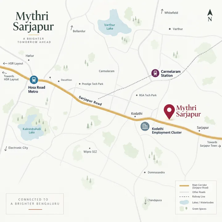
The Mythri Sarjapur location map

Every distance published on this site is a routed road distance measured from the centre of the boundary the promoter filed, not a straight line across the map.

Mythri Sarjapur location map showing Sarjapur Road, Carmelaram station and the Kodathi employment cluster
Location map; all distances published on this site are routed road distances — Mythri Sarjapur

Mythri Sarjapur location FAQ

What is the exact address of Mythri Sarjapur?

The filing places the site at Sy. Nos. 25/1, 25/4, 25/5, 26/1, 26/2, 26/3, 26/4, 26/5, 27/3 and 27/5 of Hadosiddapura Village and Sy. Nos. 28/5, 28/10, 28/12, 28/13 and 28/14 of Chikkanayakanahalli Village, Varthur Hobli, Bengaluru East Taluk, Bengaluru Urban District. Those fifteen numbers are the most useful strings a buyer holds, because they are what an advocate searches for title, encumbrance and khata, and what any plan sanction or registration must eventually attach to. Hadosiddapura holds ten of the fifteen; Chikkanayakanahalli holds the other five and is the suburb the site's coordinate resolves to. The land is declared acquired under a mix of joint-development, general-power-of-attorney, exchange and sale instruments, with only an exchange deed for Sy. 25/1 uploaded, and a joint-development agreement means landowner co-promoters will be named at registration.

What are the coordinates of the site, and how confident are you?

We publish 12.88919, 77.69780, and we label it inferred at medium-high confidence. The derivation is simple: the promoter uploaded a boundary file whose corners are 12.88760, 77.69607 and 12.89078, 77.69952, a box of about 354 m by 374 m, and our pin is the centre of it. The box is looser than the parcel, 13.2 hectares of box around 4.46 hectares of land, a fill of about 34 per cent, which is what a holding spread over fifteen survey numbers in two villages produces. The Plus Code in the circulating intake material lands about 55 m from that centre and inside the filed extent, while a decimal latitude and longitude in the same material falls outside the extent altogether and we discard it. One caution for map users: the pin reverse-geocodes to Primus Public School, which stands about 700 m away by road and is a neighbour, not part of the site.

Is the Mythri Sarjapur site inside BBMP limits, and what khata should I expect?

No. We tested the filed site centre against the Greater Bengaluru Authority boundary and the site falls outside it, about 1.65 km from the nearest edge, a margin thin enough to state precisely rather than round away and worth rechecking, because Bengaluru's corporation boundaries have been politically live since the September 2025 reorganisation. Planning here runs through the Bangalore Development Authority: every registered project this firm holds carries the BDA as its planning authority, including Sikharam on Hadosiddapura itself, on a plan sanction dated 3 May 2025. Census-derived listings place Hadosiddapura under Halanayakanahalli gram panchayat, which is a secondary source rather than a government record. Expect a panchayat khata and panchayat property tax rather than a city-corporation A-khata, and confirm the classification on these specific survey numbers.

What is the pincode, and which ward is Hadosiddapura in?

We publish 560035. It is the code the site's location returns on OpenStreetMap, it matches census-derived village listings, and it is the code the firm itself declared on three of its K-RERA records, for Street, Sapphire and Signature. It is not uncontested: the same firm declared 560087 on Sikharam, the Hadosiddapura neighbour, and on Sity. On ward numbers there is no city-corporation ward to quote, because the site tests outside the corporation boundary; the local body is the gram panchayat, and that is where a khata and a property tax receipt for this land would come from.

Where is the nearest metro station?

Hosa Road on Namma Metro's Yellow Line, 7.21 km by road, and it is a station you drive to. The Yellow Line is operational, with passenger service running since 11 August 2025 between R V Road and Delta Electronics Bommasandra. From this parcel the road ranking runs Hosa Road first, then Beratena Agrahara and Singasandra at about 8.2 km, then Electronic City at 8.82 km. Ibbaluru is nearer at 6.15 km but belongs to the Blue Line along the Outer Ring Road, which is under construction and whose stated opening target has already moved, so we publish no date for it. On the proposed Sarjapur to Hebbal line we publish nothing at all, because the alignment is still being revised and nothing is under construction.

Is there a railway station nearby, and what buses serve the area?

Carmelaram is the nearest railway station, 4.64 km by road. Note the detour: the straight line is 2.20 km, so the road takes you more than twice as far as a map implies, which is this corridor's characteristic problem and the reason we publish routed kilometres only. On buses, the confirmed fact is a metro feeder, with BMTC routes MF-22 and MF-22A running between the Electronic City Wipro main gate and the Kodathi Wipro gate about 3.5 km away by road, reported in August 2025 as eight buses across the two routes. That is a genuine link to the operational Yellow Line, and it is still a bus ride followed by a metro ride.

How far are the offices, from RGA Tech Park to the Kodathi parks?

RGA Tech Park, the anchor this firm itself uses for its Kodathi projects, is 5.41 km by road against about 1.5 km in a straight line, a detour of roughly three and a half times, which is why we publish about 5.4 km and never the word near. Wipro's Sarjapur corporate office is 4.17 km and Wipro SJP2 is 4.80 km. The Accenture and Uber offices at Kodathi are 4.53 km by road against 1.6 km straight, another near-threefold divergence, and the Wipro SEZ is 5.85 km. Embassy TechVillage is 6.42 km. Journey time on this belt is dominated by junction delay rather than kilometres, so drive the route at your own working hours before judging it.

Which schools, colleges and hospitals are closest?

The short-range social map is unusually good for a village-edge parcel. Sri Chaitanya Techno School is 0.30 km by road, Primus Public School 0.70 km, Bhoomi College 0.75 km, Prakriya Green Wisdom School 0.84 km, Bangalore Technological Institute 1.42 km and Edenbridge International School 1.58 km, which is three schools and two colleges inside 1.5 km, with Amrita Vishwa Vidyapeetham at 3.79 km. For healthcare the nearest facility is Punarjani at 1.11 km, an Ayurvedic multispeciality hospital rather than an allopathic one, and the distinction matters before you count it as emergency cover. Apollo Hospitals' Sarjapur Road facility, which the hospital group's own newsroom announced as open in July 2026, is 4.80 km by road, with Stanford Speciality Hospital at 4.67 km and Manipal Hospitals at 6.05 km.

Ask about the Mythri Sarjapur location

Ask for a routed distance to an address that matters to you and we will measure it rather than estimate it.

Contact us